My Amazing Book of Maps
Click Below Classes to View detail
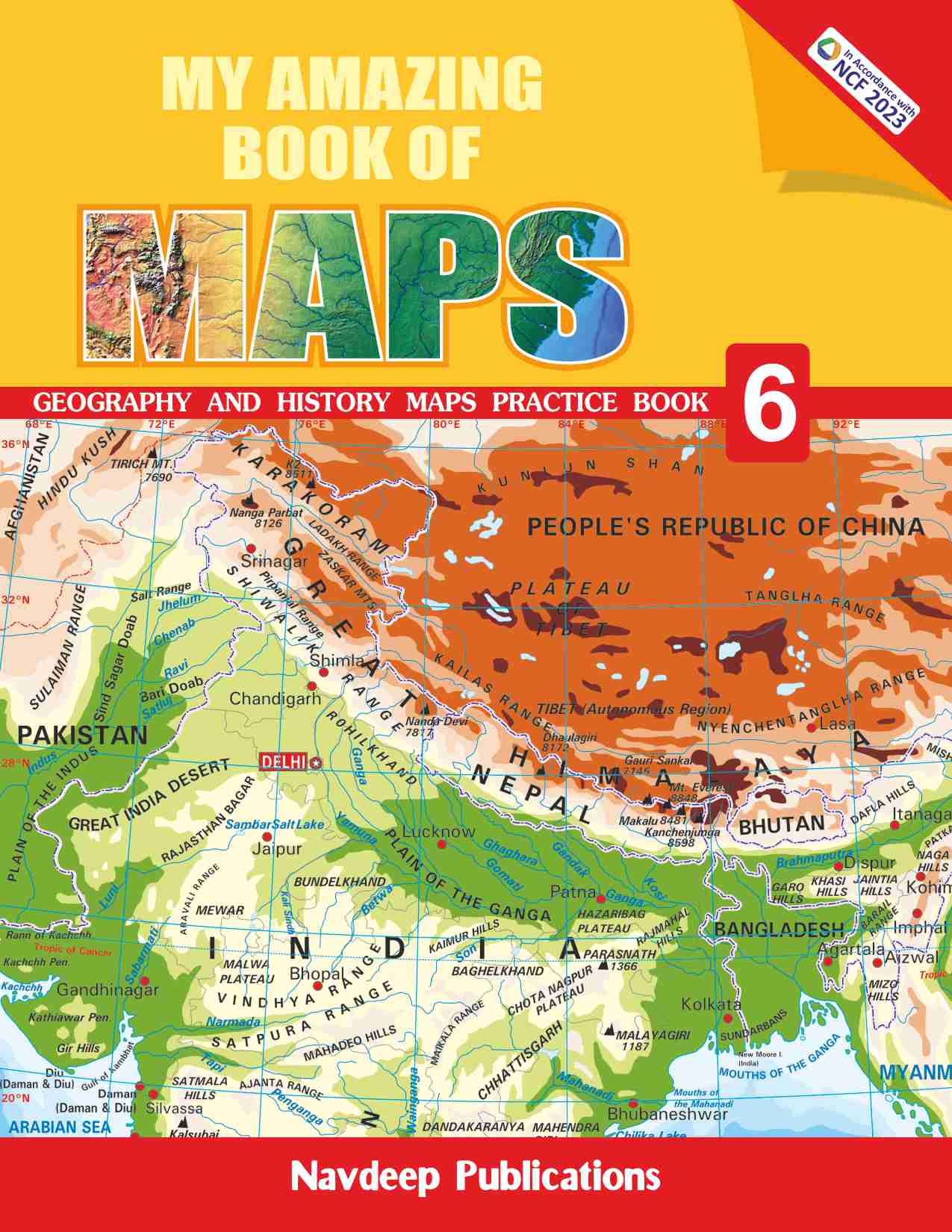
My Amazing Book of Maps-6 [Navdeep Publications ]
ISBN NUMBER : 9788175692831 PRICE : ₹ 300
General InformationGEOGRAPHY1. Globe and Maps2. ConstellationsPhases of the Moon and Solar System3. Latitudes and Longitudes4. Grid of Parallels and Meridians5. Important Latitudes and Heat Zones6. Realms of the Earth7. Longitude and Time8. Rotation of the Earth9. Revolution of the Earth and the Seasons10. World : Continents and Oceans11. World : Mountain Ranges12. India : Neighbouring CountriesGlossary (From page 8 to page 29)Worksheet – 113. India : Political14. India : Physical15. India : Physiographic Regions16. India : Major Mountains17. India : South-West Monsoon18. India : Retreating Monsoon19. India : Temperature (Winter Season)20. India : Temperature (Summer Season)21. India : Annual Rainfall22. India : Natural Vegetation23. India : WildlifeGlossary (From page 32 to page 53)Worksheet – 2Test Paper – 1HISTORY24. India : Sites of the Early Man25. India : The Indus Valley Civilisation26. India : The Vedic Age27. India : The MahajanapadasGlossary (From page 56 to page 63)Worksheet – 328. India : The Mauryan Empire29. India : In Second Century A.D.30. India : The Gupta Empire31. India : The Kingdom of Harsha32. Peninsular India (320–800 A.D.)33. India’s Contact with the WorldGlossary (From page 66 to page 75)Worksheet – 4Test Paper – 2Practice Maps
Description :
My Amazing Book of Maps series is based on the latest prescribed curriculum of the Social scineces. The Series covers relevant and contemporary topics prescribed in the Social Scinece Textbooks of Classes 6th to 10th. Maps are an absolute necessary tool of a geographer. He needs them to understans events, facts and environmental themes. Today, maps have become absolutely essential not only for the study of Geography but also for other disciplines. Map reading will make children familiar, better informed and more disciplined students of tommorow. The series has been updated as per the NCF 2023.
My Amazing Book of Maps-7 [Navdeep Publications ]
ISBN NUMBER : 9788175692848 PRICE : ₹ 325
General InformationGEOGRAPHY1. Components of the Natural Environment2. Interior of the Earth3. Rocks and Minerals4. Changing Landforms5. The Rock Cycle6. World : Volcanic RegionsEarthquake Belts and Lava Plateaus7. The Structure of the Atmosphere8. Permanent Pressure Belts9. World : Major Water Bodies10. World : Ocean’s Salinity and Temperature11. World : Ocean Currents12. World : Natural VegetationGlossary (From page 14 to page 35)Worksheet – I13. World : Major Rail Routes14. World : Major Air and Sea Routes15. World : Major Grasslands16. Tropical Regions : Amazon Basin (South America)17. Sub-Tropical Regions : Ganga-Brahmaputra Basin (India)18. World : Hot and Cold Deserts19. Temperate Regions—Prairies (North America)20. Temperate Regions—High Veld (Africa)21. Hot Desert : Sahara (Africa)22. Cold Desert : Ladakh (India)Glossary (From page 38 to page 57)Worksheet – IITest Paper – IHISTORY23. India : AD 700 – AD 120024. India : Empire of Ghori (AD 1173 – AD 1206)25. India : Delhi Sultanate in AD 123626. India : Empire of Ala-Ud-Din Khalji (1296 – 1316 AD)27. India : Empire of Muhammad Bin Tughlaq (1320 – 1413 AD)28. India : Lodhi Empire (1451 – 1526 AD)29. India : Late 14th and Early 15th Century AD30. India : Empire of Sher Shah Suri (1540–1545 AD)Glossary (From page 60 to page 75)Worksheet – III31. India : Mughal Empire — Akbar32. India : FortsPalaces and Other Buildings33. India : TempleTowns and Pilgrimage Centers34. India : Some of the Major Indian Tribes35. India : The Bhakti Saints and the Regions Associated with Them36. India : Centres of Regional Culture (Paintings)37. 18th Century : Political Formation38. India : Marathas in the 18th Century39. India : Mughal Empire (Aurangzeb)40. India : Marathas In 1680 A.D.Glossary (From page 78 to page 93)Worksheet – IVTest Paper – II
Description :
My Amazing Book of Maps series is based on the latest prescribed curriculum of the Social scineces. The Series covers relevant and contemporary topics prescribed in the Social Scinece Textbooks of Classes 6th to 10th. Maps are an absolute necessary tool of a geographer. He needs them to understans events, facts and environmental themes. Today, maps have become absolutely essential not only for the study of Geography but also for other disciplines. Map reading will make children familiar, better informed and more disciplined students of tommorow. The series has been updated as per the NCF 2023.
My Amazing Book of Maps-8 [Navdeep Publications ]
ISBN NUMBER : 9788175692855 PRICE : ₹ 325
General InformationGEOGRAPHY1. World : Major Land Use2. India : Main Soil Types3. World : Means of Irrigation4. World : Minerals –I5. World : Minerals –II6. World : Major Coalfields7. World : Major Oilfields8. India : Minerals –I9. India : Minerals –II10. World : Arable Land11. World : Types of Forests12. World : Major Grasslands13. World : Main Types of Agriculture14. India : Power Resources-I15. India : Power Resources-II16. India : Hydel Power ProjectsGlossary (From page 8 to page 35)Worksheet – 117. World : Crops – I18. World : Crops – II19. World : Crops – III20. World : Crops – IV21. World : Crops – V22. World : Crops – VI23. India : Crops – I24. India : Crops – II25. India : Crops – III26. India : Crops – IV27. India : Crops – V28. India : Crops – VI29. World : Major Industrial Regions30. World : Iron and Steel Industry31. World : Textile Industry32. World : Information and Technology33. World : Density of Population34. India : Industrial Regions35. India : Iron and Steel Industry36. India : Cotton Textile Industry37. India : Growth of Population38. India : Sex Ratio 201139. India : Effective Literacy Rate-2001-201140. World : Earthquake Belts41. India : Seismic Zones42. India : Flood Prone Areas43. India : Drought Prone Areas44. India : CyclonesGlossary (From page 38 to page 71)Worksheet – 2Test Paper – 1HISTORY45. Routes to India in the Eighteenth Century46. India : 1705 AD – European Companies47. India : 1765 AD48. Location of Some Tribal Groups in India49. India : Main Centres of Revolt 1857 AD50. Main Weaving Centres in late 18th CenturyGlossary (From page 74 to page 85)Worksheet – 351. India : Centres of Religious and Social Reform Movements52. Important Centres of National Movements (1905-1947)53. Indian Provinces and Princely States before 14 August194754. India : The Making of Linguistic States55. Indian States in 1975Glossary (From page 88 to page 97)Worksheet – 4Test Paper – 2Practice Map
Description :
My Amazing Book of Maps series is based on the latest prescribed curriculum of the Social scineces. The Series covers relevant and contemporary topics prescribed in the Social Scinece Textbooks of Classes 6th to 10th. Maps are an absolute necessary tool of a geographer. He needs them to understans events, facts and environmental themes. Today, maps have become absolutely essential not only for the study of Geography but also for other disciplines. Map reading will make children familiar, better informed and more disciplined students of tommorow. The series has been updated as per the NCF 2023.
My Amazing Book of Maps-9 [Navdeep Publications ]
ISBN NUMBER : 9788175692862 PRICE : ₹ 335
GEOGRAPHY1. Location of India in the World2. India : Extent and Standard Meridian3. India : International Highway of Trade and Commerce4. India and the Neighbouring Countries5. India : Political Divisions6. Major Plates of the Earth's Crust7. India : Physical Divisions8. India : Physical Features9. India : Mountain Ranges10. India : Rivers and Lakes11. India : River Basins12. India : Temperature and Atmospheric Pressure – January13. India : Average Rainfall – January14. India : Temperature and Atmospheric Pressure – April15. India : Temperature and Atmospheric Pressure – July16. India : Onset of Monsoon17. India : Average Rainfall – July18. India : Seasonal Rainfall (June–September)19. India : Temperature and Atmospheric Pressure – October20. India : Retreating Monsoon21. India : Average Annual Rainfall22. India : Natural Vegetation23. India : Wildlife24. India : Density of Population (2011)25. India : Growth of Population (2001–2011)26. India : Sex Ratio – 201127. India : Literacy Rate – 201128. India : Female Literacy Rate – 201129. India : Urban Population Map for PracticeHISTORY30. Europe : Before the French Revolution in 1789 AD31. France : Spread of the Great Fear32. The French Revolution and Europe in 1810 AD33. Europe in 1914 ad During the First World War34. Germany after the Treaty of Versailles35. The War Against Bolshevism1918 – 1919 AD36. Europe in 1942 AD : Expansion of the Nazi Power37. The Communist Government in Europe After the Second World War38. Forest Transformation in Indonesia39. Pastoral Communities in India40. Pastoral Communities in Africa41. The Captain Swing Movement1830 – 1832 AD42. Enclosure of the Common Fields by Parliamentary Acts43. Forests and Grasslands in usa before the Westward Expansion of the White Settlers44. The Agricultural Belts in usa in 1920 AD45. The Westward Expansion of the White Settlement1775 AD46. The Westward Expansion of the White Settlement1830 AD47. The Westward Expansion of the White Settlement1850 AD48. The Westward Expansion of the White Settlement1920 AD49. The Triangular Trade50. Cricket and ColonialismMap for Practice
Description :
My Amazing Book of Maps series is based on the latest prescribed curriculum of the Social scineces. The Series covers relevant and contemporary topics prescribed in the Social Scinece Textbooks of Classes 6th to 10th. Maps are an absolute necessary tool of a geographer. He needs them to understans events, facts and environmental themes. Today, maps have become absolutely essential not only for the study of Geography but also for other disciplines. Map reading will make children familiar, better informed and more disciplined students of tommorow. The series has been updated as per the NCF 2023.
My Amazing Book of Maps-10 [Navdeep Publications ]
ISBN NUMBER : 9788175692879 PRICE : ₹ 375
GEOGRAPHY1. India : Political Divisions2. India : Major Soil Types3. India : Land Utilization4. India : Forest Areas 20115. India : Wildlife6. India : Major Rivers and Dams7. India : River Basin8. India : Means of Irrigation9. India : Net Sown Area Under Irrigation10. India : Intensity of Cropping - 201111. India : Deserts12. India : Main Rice Produting Areas13. India : Main Wheat Producting Areas14. India : Sugarcane and Spices15. India : CottonJute and Rubber Producting Areas16. India : CoffeeTea and Tobacco Producting Areas17. India : Coalfields18. India : Oilfileds and Pipelines19. India : Nuclear and Thermal Power Stations20. India : Major Hydel Power Stations21. India : Iron-ore Mines22. India : Iron and Steel Plants23. India : Other Minerals24. India : Textile industries25. India : Agro-based Industries26. India : Forest-based Industries27. India : ChemicalCement and Fertilizer Industries28. India : Transport Based Industries29. India : Software Industries30. India : Major Rail Routes31. India : Golden Quadrilateral Railways Route32. India : National Highway33. India : National Highway Development Project34. India : Major Air Routes35. India : Major Seasports36. India : Incidence of Poverty37. Tsunami : The Killer Sea Waves38. India : Seismic Zones39. India : Major Earthquake40. India : Flood Prone Areas41. India : Major Landslides42. India : CyclonesMap for PracticeHISTORY43. Europe after the Congress of Vienna 1815 AD44. Habsburg Empire 1848 AD45. Unificaiton of Germany 1866 - 1871 AD46. Italian States before the Unification 1858 AD47. Italian States after the Unification48. Location of Indo-China49. Nationalists Movements in Indo-China50. The ho Chi Minh Trail51. India : Main Centres of the Freedom Movements52. India : Main Centres of the Freedom Movements 1857 AD53. India : Main Centres of the Peasant Movements in Early 19th Century54. India : Main Centres of the Tribal Movements in Early 19th Century55. India : Main Centres of the Peasant & Workers Movements in the 20th Century56. India : Main Centres of the Non-Cooperation Movement57. India : Main Centres of the CIvil-Disobedience Movement58. India : Main Centres Associated with the Indian Naitonal COngress 1885 -1947 AD59. Colonical Africa at the End of the 19th Century60. Independent Nations of Africa61. The Trade Routes that Linked India to the World at the End of the 19th Century62. Industrial Revolution in England 1780 - 1850 AD63. India : Location of Large-Scale Industries 1931 AD64. Growth of London (1600 - 1900 AD)65. BombayMap for Practice
Description :
My Amazing Book of Maps series is based on the latest prescribed curriculum of the Social scineces. The Series covers relevant and contemporary topics prescribed in the Social Scinece Textbooks of Classes 6th to 10th. Maps are an absolute necessary tool of a geographer. He needs them to understans events, facts and environmental themes. Today, maps have become absolutely essential not only for the study of Geography but also for other disciplines. Map reading will make children familiar, better informed and more disciplined students of tommorow. The series has been updated as per the NCF 2023.